- Client
- SXSW London 2026
- Industry
- Conference, music, screen, technology and culture
- Location
- Shoreditch, London
- Event scale
- 850+ speakers · 250+ music artists · 150+ screenings · 750+ companies · 90+ partners · 100+ countries
- Delivered
- April 27, 2026
- Event dates
- June 1–6, 2026
- Public map
- sxswlondon2026.expofp.com
- Scope
- Multi-venue structure · Venue and stage markers · POIs · Partner areas · Mobile-friendly search · Analytics
SXSW London is the UK edition of SXSW, bringing conference, music, screen, technology, creativity, and culture programming together in one international festival. Held across Shoreditch from June 1–6, 2026, the six-day event reported 850+ speakers, 250+ music artists, 150+ screenings, 750+ companies attending, 90+ partners, and participants from 100+ countries.
For an event built around discovery, the challenge is not only what is happening, but how people move between it. Attendees needed a clear way to explore venues, stages, points of interest, partner areas, and other event locations without relying only on a static reference. SXSW London needed a centralized, branded map that could support navigation before and during the live event — and provide measurable evidence of how people used it.
The challenge: navigation across a multi-venue festival
SXSW London combined programming, partners, activations, and attendee touchpoints across multiple locations in Shoreditch. With so much happening at once, people needed a practical way to understand where activities were taking place and how the different areas connected.
A static map would have been limited for a high-traffic, discovery-driven event. The experience needed to make venues, stages, points of interest, and key locations easier to find from a phone, while giving the organizer a consistent public-facing map that could be shared throughout the event journey.
The map also needed to create a measurable digital layer. Tracking views, loads, sessions, and users would show whether attendees were actively engaging with the map rather than simply having access to it.
For a multi-venue festival, the map is not just orientation — it is part of discovery.
What the organizer wanted to achieve
The project had four clear goals:
- Launch a branded, mobile-friendly interactive map for the SXSW London 2026 event experience.
- Make venues, stages, points of interest, partner areas, and key locations easier to discover.
- Support attendee navigation before and during the June 1–6 event week.
- Capture reliable usage data through the ExpoFP analytics dashboard.
The map was connected not only to orientation, but also to attendee discovery and partner visibility. A clearer digital experience supported all three at the same time.
ExpoFP's solution
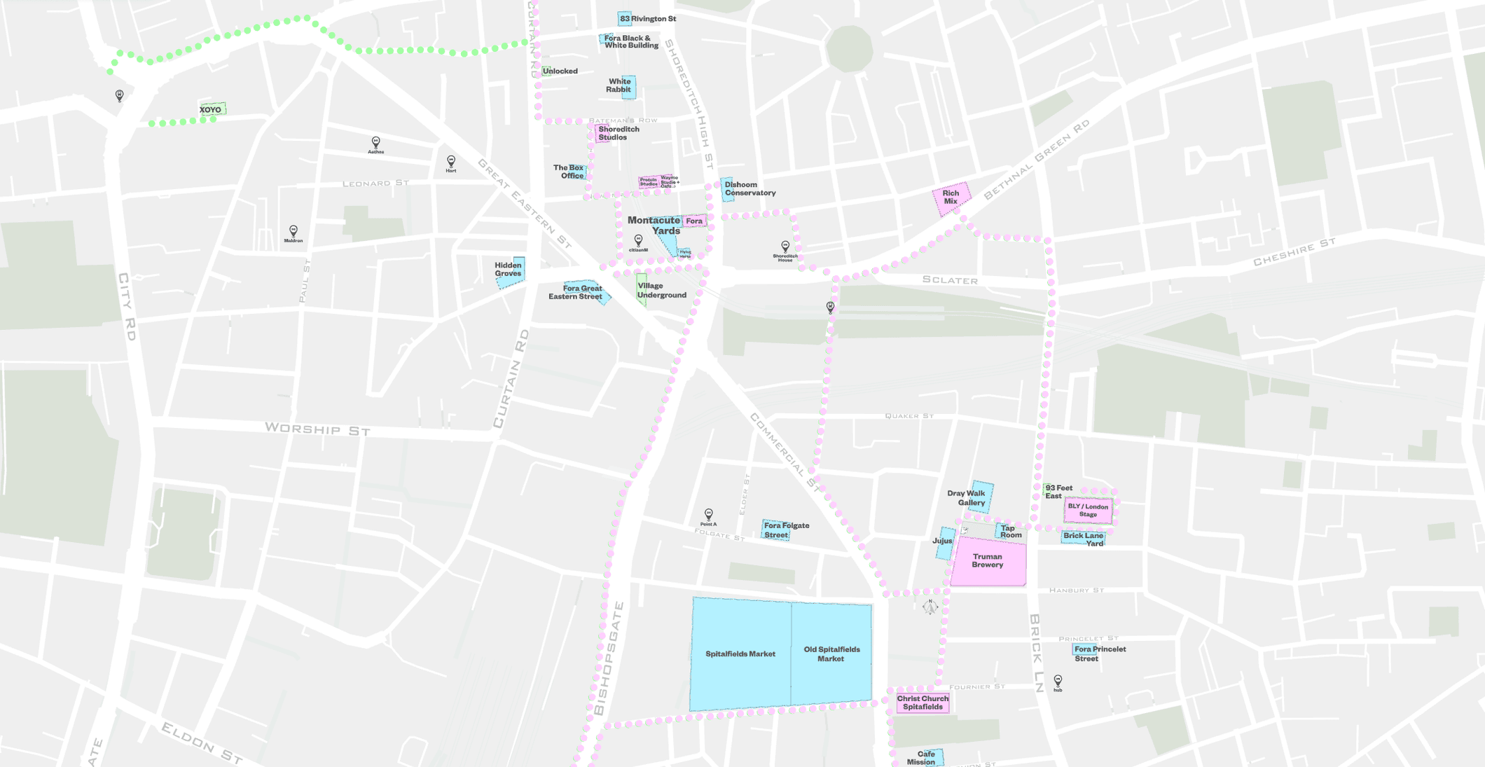
ExpoFP built and published a centralized interactive event map for SXSW London 2026. The project transformed the event layout into a branded, shareable digital experience that users could explore across venues and event areas.
The delivered scope included:
- Branded interactive event map for SXSW London 2026
- Multi-venue structure covering key locations across Shoreditch
- Venue, stage, point-of-interest, and event-location markers
- Searchable and mobile-friendly map experience for attendees
- Visibility for partner areas, activations, and other attendee touchpoints
- Public map hosted at sxswlondon2026.expofp.com with analytics tracking
A branded, multi-venue interactive map for SXSW London 2026 — connecting venues, stages, points of interest, and partner areas in one public experience used by 6,106 people during the measured period.
How the project was delivered
ExpoFP organized the work around four stages, from structuring a complex multi-venue event to publishing the map and measuring how it was used.
1. Planning
ExpoFP reviewed the needs of a large event spread across Shoreditch and organized the map around venues, stages, points of interest, partner areas, and the attendee touchpoints that mattered most.
2. Map build
The SXSW London 2026 interactive map was built with event locations, labels, markers, and a branded visual structure designed to make a complex layout easier to explore.
3. Publication
ExpoFP published the public map at sxswlondon2026.expofp.com, creating one centralized destination that users could access before and during the event.
4. Launch and measurement
The map was delivered on April 27 and made available as a live navigation and discovery tool ahead of the June 1–6 event week. ExpoFP analytics then tracked views, loads, sessions, and users during the measured period.
What the numbers show
ExpoFP analytics recorded the following engagement during the measured event period:
More than 6,100 people used the SXSW London 2026 map during the measured period, generating 6,734 sessions and 10,130 total views. That level of usage shows the map became an active part of the event experience rather than a static resource that attendees overlooked.
The difference between unique users (6,106), sessions (6,734), and total views (10,130) indicates repeat interaction. Users returned to the map as they moved through the event and needed to find different venues, stages, points of interest, or partner areas.
Because the map was public, mobile-friendly, and centralized, it gave users one consistent place to explore the event layout before and during the live week.
Source: ExpoFP analytics dashboard. Timeframe: measured dashboard period for SXSW London 2026; event week June 1–6, 2026. Values are exact. Event scale figures are from the SXSW London case-study brief.
Why this case matters for ExpoFP prospects
This case is a useful reference for:
- Large festivals and conferences spread across multiple venues or locations
- Events combining content, networking, sponsors, partners, and attendee discovery
- Organizers that need a branded interactive alternative to a static event map
- Teams that want to make venues, stages, points of interest, and activations easier to find
- Events that need measurable map engagement and usage data
It shows that ExpoFP can support a large, discovery-driven event with a public interactive map that helps users navigate a complex layout and produces measurable engagement at scale.
Final takeaway
At a multi-venue festival, the map is the connective layer between the program and the place. SXSW London 2026 gave attendees a centralized way to discover locations across Shoreditch, while the analytics confirmed that thousands of users actively relied on the experience.